The three-mile-high club
This paper examines the problematic use of satellite imagery in claims of human rights abuses in Xinjiang, China. Specifically, it critiques the work of Nathan Ruser, whose identification of "concentration camps" based primarily on the presence of guard towers is challenged. The paper argues that such visual cues, while suggestive, cannot definitively determine the nature of activities within a facility. Furthermore, it highlights the flawed logic of extrapolating cultural erasure from observed changes in mosque architecture via aerial imagery. The paper emphasises the necessity of ground-level verification for any conclusions drawn from aerial surveys, a standard practice ignored by Ruser. Ultimately, this analysis demonstrates the potential for significant misinterpretations when relying solely on remote sensing data.
The background
ASPI researcher, Nathan Ruser, published a detailed record of sites in Xinjiang, China, that, from satellite imagery, were declared to be “concentration camps”. The features used to distinguish these camps were, almost exclusively, “guard towers”. Guard towers throw a distinct shadow on the ground and the pattern of these towers around the perimeter implies a secure enclosure. In Australia, they would signal a prison or detention centre.
Ruser's work was lauded as exposing a regime of imprisonment and torture of Uighur people, supposedly for innocuous activities like "growing a beard". But the nature of the treatment of the Uighurs in deradicalisation was speculation, and the presence of security features provided no information on this treatment. A person can be tortured in an invisible bunker. Conversely, completely innocent activity can take place in high security environments.
Regardless of the use suggested by "guard towers", drawing conclusion about the nature and purpose of buildings from “three miles up” (as Jerry Grey describes it) is absurd. Ruser's work was used elsewhere to 'support' the notion that changes in mosques, both in local and structure, implied a pattern of destruction of mosques and hence cultural erasure. It was widely heralded as good 'evidence' of China's cultural erasure of Uighur culture.
Aerial surveys, even those using sophisticated technologies such as LiDAR, require surface level verification. This is standard practice for industries, such as agriculture, who rely on these technologies. Ruser, had he had any genuine expertise, would have realised this and insisted that all his images were verified independently 'on the ground'.
Industry techniques and Ruser's ignorance aside, this analysis provides an example of how aerial surveys can be entirely misleading.
When is a house not a house?
I want to take you down a pathway of discovery that highlights the ridiculous nature of the ASPI methodology.
Observe the photo below. It is snipped from Google Maps at only 500 metres. What do you see? A farm, perhaps.
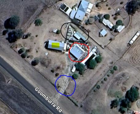
Goomburra church image at 500 metres
The blue circle indicates a track that leads in from a road. A building is circled in red. On top of this building is the unmistakable pattern of solar panels. The area in the black circle appears to have sheds of some kind. And the yellow highlight is another building, perhaps a house, given the peaked roof.
So, what is this place? A residential block in an urban setting. Probably not. The open ground suggests rural or semi-rural. So, how would you determine the function of each building or area? Most reasonable people would say - visit and see. Verify at ground level. So, here’s the surprise.
The church
This is the same location.
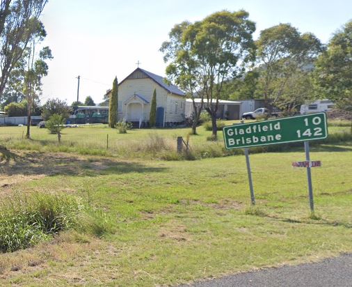
Goomburra church
Church?
So, what goes on inside? Prayers? Sermons? If you chose either of those, you’d be wrong. Here is another view of the shed.
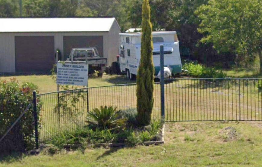
Goomburra church renovations
Signs and wonders
The sign gives away what is happening here. An owner builder is renovating a church building. In the picture we see the caravan that was home until the shed was built. Meanwhile, the church underwent renovations to make it a home.
I only know this because I have driven by this place for the last 40 years. I knew it once as a church. I have watched the development of it as a home. Any place has a history and this is not available from 3 miles up via images.
But, why is it now a home? If I were able to show you the answer to that question using satellite imagery, I would be omnipresent in a way that only God can claim to be.
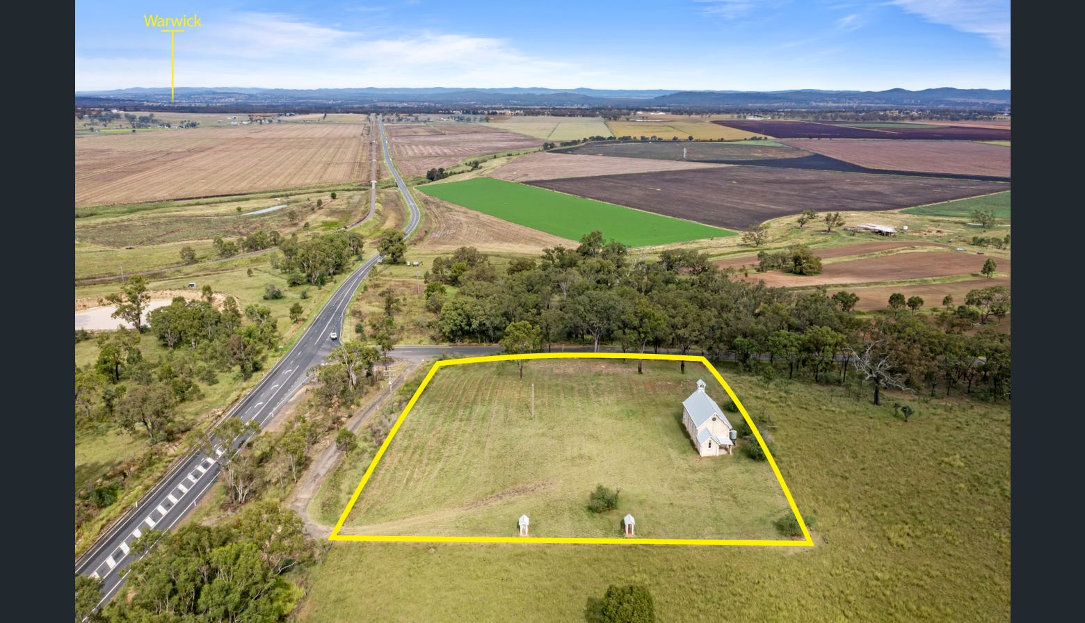
Deuchar church advertised for sale. Sold, due to declining attendance.
But, since I have looked into this, here is the story.
The area in which this church stands is rural Queensland. Rural Queensland has suffered a gradual by steady decline in its economy. Being a farmer in this district is a challenge. Commodity prices fluctuate wildly. ‘Working the land’ is only for the brave. A light shower of rain can reduce the value of your crop by thousands of dollars in five minutes.
In the face of this decline, church attendance across the region, especially in small churches in outlying areas, has also declined. Young people are not attending church as frequently and competition from more ‘effervescent’ churches also contributes to the decline.
Images that answer no questions and add no information
Hence, at some point, the central church organisations have shut down churches and sold off the properties, often just to sustain their finances, which have also, logically, declined. This is one such church.
Did an authoritative government declare Christianity illegal and this led to the church closure? Are the locals frightened to attend? Did non-Christian people move to the area, thus changing the local culture irreparably? We simply cannot tell.
The sheer ludicrousness of imagining that the story of what occurs at ground level can be ascertained by satellite imagery, illustrated in this ‘parable’, reflects the vacuous methodology of ASPI. I can spin any kind of narrative I wish about a church or supposed ‘concentration camp’. In the end, as evidence, these satellite images can be dismissed as the garbage that they are.
ASPI has had years to verify their nonsensical claims by ground level observations and photography. To date, it is simply missing.
Sources
Claims
Author
Andrew Westerman
I am a retired teacher who has an interest in geopolitics and preventing a war between the US and China